

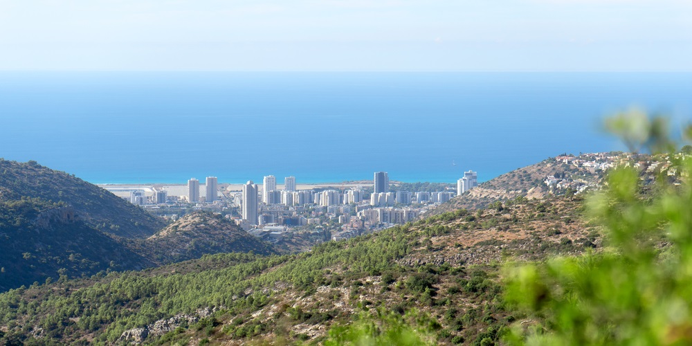
The District of Haifa is one of the seven administrative districts of Israel surrounding Haifa, with a total surface of 864 square kilometres. Haifa is the third biggest city in Israel and the primary urban centre of northern Israel, and it is one of the most prominent seaports of the Mediterranean Sea. The Haifa suburbs are Baqa al-Gharbiyye, Hadera, Haifa, Kiryat Ata, Kiryat Bialik, Kiryat Motzkin, Kiryat Yam, Nesher, Or Akiva, Tirat Carmel, Umm al-Fahm. The southern cities are Baqa al-Gharbiyye, Hadera, Nesher, Or Akiva, Tirat Carmel, Umm al-Fahm.

Baqa al-Gharbiyye
Baqa al-Gharbiyye is an Arab city located in the Triangle region of Israel close to the Green Line, also called the 1967 border or 1949 Armistice border. The demarcation line was defined in the 1949 Armistice Agreements between the Israeli armies and the neighbour countries: Egypt, Jordan, Lebanon and Syria after the 1948 Arab-Israeli War. Archaeologists discovered ancient remnants of Baqa al-Gharbiyye dating back to the Intermediate Bronze Age, Iron Age II and Hellenistic periods. Moreover, other discoveries include an olive press, quarries and a winepress dating back to the Hellenistic or Early Roman period, ceramics from the late Roman or early Byzantine periods, and a burial cave with historical remnants from the Byzantine and the early Umayyad periods. During the Crusader and Mamluk periods, in 1265, Sultan Baibars split the village between the ‘Ala’ al-Din Taibars al-Zahiri and Ala’ al-Din ‘Ali al-Tunkuzi emirs. Since 1538, Baqa was under the control of the Ottomans, who described the town in a document as a village. In 1870, the explorer Victor Guérin described the village of Bakah as a place, which was located on a low hill, featured by ancient wells and cisterns, and with a population of almost 1500 inhabitants.
In 1882, Baqa al-Gharbiyye was a small village with some olive trees and orchards in the southern area. During the British Mandate, in 1922, Baqa Gharbiyeh was inhabited by 1442 Muslims and an Anglican Christian. And in 1931, the census of Palestine recorded a population of 1640 Muslims, including the town of El Manshiya. Between 1936 and 1939, the Arab Revolt occurred with clashes and battles between the British troops and the Arab militants. On 26th August 1938, the British government commanded the Arab villagers to leave their houses without carrying anything, driving them to a nearby camp. The village was burnt and destroyed, being one of the most violent attacks of the British government on a Palestinian village. In 1945, the population of Baqa al-Gharbiyye and Manshiyat Baqa consisted of 2240 Muslims in a total area of 21116 meters square, whose majority was employed for plantations and cereal cultivation. Once After the Israel Independence Declaration, Baqa al-Gharbiyye became one of the bases of the Israeli military administration. In 1996, Baqa al-Gharbiyye became a declared city, and later, in 2003, it was merged with the close town of Jatt, becoming Baqa-Jatt. In 2019, the town of Baqa al-Gharbiyye consisted of 29 thousand inhabitants who are Muslim Arabs without any Jewish population. Baqa al-Gharbiyye is a commercial and industrial centre among all the nearby cities, kibbutzim, towns, and villages.
Hadera
The city of Hadera belongs to the Southern Haifa District in Israel, and it is located in the northern Sharon region, 45 km from Tel Aviv and Haifa. Hadera stretches over 7 km along the Israeli Mediterranean Coastal Plain.

The main population of Hadera consists of immigrants from the former Soviet Union and Ethiopia. Hadera was founded in 1891 as an agricultural settlement by the Zionist group Hoverei Zion from Latvia and Lithuania. In 1952, Hadera became a city with a total area of 53 square kilometres. Initially, the area inhabitants were families living of water buffaloes farming and papyrus reed cultivation. In the beginning, Hadera was a village under the name of Wadi al-Khudeira. During the Crusades, Hadera was named Lictera. After the foundation of Hadera, the city name was reported as the “moshav of Hadere” or Hatzor, although during World War I, the British named it Liktera. Hadera was founded in the location of the ancient city of Hedera of Caesarea, as Yitzhak Goldhar, the surveyor of Baron Edmond James de Rothschild, claimed. The historian and biblical archaeologist Benjamin Mazar selected the location of the ancient Gador or Gedera by Caesaria in Tell Ahḍar, which was also named Tell esh Sheikh Ziraq and it is the actual Tel Gador in the south coast of Giv’at Olga. The early Jewish immigrants lived in a building named Khan close to the existing main synagogue of Hadera, and the population counted ten families and four guards. In the first part of the 20th century, Hadera became an economic centre in Israel, with vineyards and fields extending over 30 squared kilometres. In 1922, During the British Mandate, the population of Hadera consisted of 540 inhabitants with 450 Jews, 89 Muslims, and 1 Christian.
Nevertheless, in 1931, the population grew to 2002 people. After the 1948 War, Hadera expanded, and the population grew, especially when new immigrants arrived in Israel. Besides the newcomers from Europe, other settlers originated from Yemen. The city of Hadera went through economic development, especially after the first paper mill opened in 1953, Hadera Paper, thanks to investors from Australia, Brasil, USA and Israel.
Moreover, new neighbourhoods such as Givat Olga along the Mediterranean coast and the easter area of Beit Eliezer were built. Finally, in 1964, Hadera became a declared city, and in the 1990s, a new wave of immigrants coming from Russia and Ethiopia contributed to the city’s growth. During the 2000s, the city centre of Hadera was restored, and a high-tech business park was built.
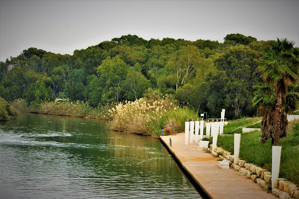
Additionally, Hadera owns the largest desalination plant in the world, and it is a tourist destination also because of its closeness to Galilee and its beautiful beaches. Hadera rises on the Israeli Mediterranean Coastal Plain, which is 45 km north of Tel Aviv. Since the total surface of the city is 53 square kilometres, Hadera is the fourth biggest city of Israel after Jerusalem, Tel Aviv and Haifa. In Hadera, there is a beautiful eucalyptus forest known as Nahal Hadera Park, with a total surface of 1.3 square kilometres, besides the Hasharon Park situated in the suburbs of Hadera. A particular phenomenon of Hadera is the hot water pouring out of the Hadera power plant that attracts hundreds of dusky sharks and sandbar sharks every year during the wintertime. The water becomes ten degrees warmer than the rest of the sea. The city of Hadera is located between two main Israel Railways lines: the Coastal Line and the Eastern Line. The Hadera railway station is in the city’s western area, and it belongs to the Tel Aviv suburban railway line between Ashkelon and Binyamina. The Hadera city centre is located between two main highways: Highway 2 connecting Tel Aviv to Haifa and Highway 4. Hadera Paper, the world’s biggest desalination plant since 1953, persists in being one of the most important employment poles of the city.
Moreover, Hadera hosts the largest power station in Israel that is named Orot Rabin. Since 1948, the population of Hadera has grown continuously, counting a total population of 97334 inhabitants in 2019, whose the 91.8% were Jewish and 0.9% Arab. A famous medical institution of Hadera is the Hillel Yaffe Medical Center, and a notorious educational, scientific and technological centre is the Technoda, with an advanced telescope and planetarium in the Givat Olga neighbourhood. The neighbourhoods of Hadera are Beitar, Beit Eliezer, Bialik, Bilu, Ephraim, Givat Olga, Haotzar, Hephzibah, Kfar Brandeis, Klarin, Nahaliel, Neve Haim, Nissan, Pe’er, Shimshon, Shlomo, and The Park.
Nesher
Nesher is another city in the Southern District of Haifa in Israel. This city arose as a workers’ town in 1924 because of the Nesher Cement factory that became the first cement factory in Israel. Nesher had been established by the Russian Jewish industrialist Michael Pollack in 1923 in a location that was muddy and infested by malaria. With time, an increasing number of factory employees settled in the town that consisted of 1500 inhabitants in 1925. In 1929, the Arabs of Balad al-Sheikh destroyed the factory, and in the mid-1930s, Nesher Cement employed 700 people; among them, half were Jews and half Arabs. In 1948, Jewish newcomers from Europe, Iraq and North Africa immigrated to Nesher, which expanded in the years and in 1952, it consisted of four neighbourhoods: Ben-Dor, Giv’at Nesher, Nesher, and Tel Hanan, with a local council.

The heraldic design of the coat of arms of Nesher was designed by David Hollod with some peculiar references such as the eagle that represents the name of the city and the cement factory, and the four hills symbolize the mountainous area of Nesher and the four earlier neighbourhoods. Other references of the Nesher coat of arms are the factory and chimney that symbolize the industrial feature of the city’s establishment and the tree representing the economic and social growth of Nesher with time.
Or Akiva
Or Akiva is a city of the Southern Haifa district that owns its name to the famous sage Rabbi Akiva. Or Akiva is located in the coastal plain in Israel like all the other cities situated in the Southern area of the Haifa area. This city is positioned in the inward area close to the ancient city of Caesarea along the Mediterranean Sea and in the north of Hadera. Or Akiva is located 39 km from Tel Aviv and 48 km from Haifa. Most of the population of Or Akiva is Jewish, and this city hosts big industrial plants such as the professional skincare Anna Lotan Ltd., the plastic packaging Darbox Ltd., the pharmaceutical Dexxon, the gunsights and night vision Meprolight, the livestock feeders Plasson, the STI Laser Industries Ltd. and the electronics Tyco International.
Tirat Carmel
Tirat Carmel belongs to the Southern District of Haifa in Israel. During the centuries, this city has been ruled by many civilizations such as the Ottomans, Romans and British. Tirat Carmel was erected in the location of the remnants of the town al-Tira. During the Crusades, the city was named St. Yohan de Tire, and the Ottomans ruled the town during the late Middle Ages and Renaissance. The main source of Tirat Carmel was the agriculture of mainly wheat and the goats’ farming. In 1945, The town hosted a Muslim agricultural community with few Christians, and it was a well-known place for the production of almonds and olives.
In 1949, new Jewish immigrants settled in Tirat Carmel thanks to two absorption centres that later in 1959 became the municipality of the town where the majority of the population consisted of Jews. Among the notable people who were born in Tirat Carmel, there is the very famous actor, musician, bassist, singer and co-lead singer of the legendary rock band Kiss that was founded in New York in 1973 by Gene Simmons, Ace Frehley, Paul Stanley and Peter Criss.
Umm al-Fahm
Umm al-Fahm is another city of the extensive Southern District of Haifa that is 20 km far from Jenin. In 2019, the city consisted of 56109 Arabs who are citizens of Israel. The name of the city is due to the fact that the town is located on the Umm al-Fahm mountain ridge, whose highest point is Mount Iskander at 522 metres above sea level with a view over the Wadi Ara valley. Umm al-Fahm is the cultural, economic and social centre of the Wadi Ara and Triangle Regions in Israel. The name Umm al-Fahm comes from the Arabic word “Mother of Charcoal” because this village was encompassed by forests that were a source of charcoal. The first archaeological remnants of the city date back to the Iron Age II, and there are also traces of other periods such as Hellenistic, early Muslim and Middle Ages, the Persian and Roman. During the Mamluk domination, in 1265 C.E., after the fourth Mamluk sultan of Egypt, Baibars Abu al-Futuh, conquered the territory, defeating the Crusaders, all the revenues of Umm al-Fahm were the property of the Mamluk viceroy of Syria Jamal al-Din al-Najibi. During the Ottoman era, in 1517, the town was part of the Ottoman Empire, like the rest of the country, and during the following years, the population consisted of 24 Muslim households who were taxed on farming products such as barley, olive trees, wheat, and animals such as goats and beehives. In the following centuries, Umm al-Fahm was a favoured destination among the explorers and archaeologists, such as Victor Guérin, who described the town as inhabited by 1800 residents and with fantastic gardens, and Charles Tyrwhitt-Drake, who noticed that Umm al-Fahm was divided in four quarters: El Akbariyeh, El Jebarin, El Mahamin, and El Majahineh. Each district of the town had a sheikh. In 1883, the Palestine Exploration Fund’s Survey of Western Palestine depicted Umm al-Fahm as a town with 500 residents whose 80 were Christians and featured by stone constructions.
The village possessed an abundance of cattle, horses and goats, and it was an important location as well as the town of Jenin. Umm al-Fahm still was divided into four quarters, and a maqam for a Sheikh Iskander, i.e. a Muslim funeral construction, was built on a hill. In 1922, during the British Mandate, the population of this village consisted of 2183 Muslims and 8 Christians; in 1931, there were 2427 Muslims and 16 Christians, and in 1945, the total population consisted of 5430 Muslims and 60 Christians in a total area of almost 77.3 square kilometres, with plantations and irrigable land, cereals’ cultivation and urban land. After the proclamation of the Independence of Israel in 1948, Umm al-Fahm consisted of 4500 residents whose majority was a farmer.
After the 1948 Arab-Israeli War, during the Lausanne Conference in 1949, Israel was granted the Little Triangle region, and in 1949, the city became part of Israel, and its population increased fast. In 1985, Umm al-Fahm became a city where the influence of fundamentalist Islam grew; in fact, since the 1990s, the municipality had been managed by the Northern Islamic Movement, although the majority of the residents, who are Israeli Arabs, don’t want that the city goes under the Palestinian jurisdiction.
Since the earlier period of the foundation of Umm al-Fahm, the village went through different stages until it became a city. The main working sector is the building industry; other employments are clerical and self-employed jobs. A notable activity of the city is the Haat Delivery that is a food-delivery startup in Umm al-Fahm. An important cultural institution is the Umm al-Fahm Art Gallery, which was founded in 1996 as a contemporary art gallery with original Arab and Palestinian art and managed by the El-Sabar Association. In the gallery, art classes take place for Arab and Jewish children with exhibitions of Arab and Jewish artworks. The Green Carpet association promote local tourism and ecological projects in the area of Umm al-Fahm.
Hence the Southern District of Haifa is full of unique places full of history and culture. It is like being immersed in different historical periods and discovering the rich and complex history of Israel.